|
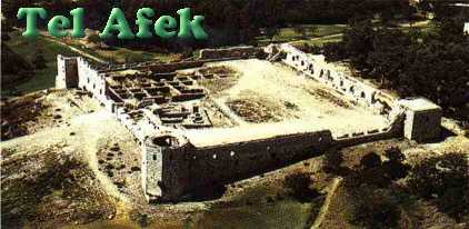
Tel Afek
by Jacqueline Schaalje
Tel Afek, also known as Antipatris, is in nearby Rosh Ha'ayin, just outside of Tel Aviv. Rosh Ha'ayin means "head of the spring", this refers to the spring that feeds the Yarkon river. The Yarkon streams onwards from Afek to the nearby lovely Hayarkon park.
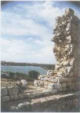
The River is seen behind the Wall
Some very early traces of history have been found in Tel Afek. The tel knew a continuous occupation of over 5000 years. Its location in ancient times was along the trade and caravan route from Egypt to Mesopotamia and Syria, which led right through Israel, or Canaan as it was known. Camels laden with goods led along this route, "The Way of the Sea", and passed through Tel Afek. As now the location was ideal for a rest from the heavy travelling, shaded by trees and with plenty of water.
With the mountains of Judaea starting 3 kilometers on the east, the little vale known as Afek Pass was easy to defend and the first towns were soon founded. What are among the oldest archaeological remains in Israel have been discovered in the form of thick defending walls. They belonged to the early Bronze Age, the oldest period in which towns were built in Israel. The name of the settlement was Afek, this we know from Egyptian pottery shards from the 20th Century BCE, known as the "Execration Texts": a list of cities in Israel which the Egyptians wanted to destroy. Jerusalem and Ashkelon also feature on this list for the first time in history.
Not all of the cities on the list were really smitten, but the Egyptians did indeed rule in Afek for a long time, as in probably large parts of the coast of Israel. In Afek the house of the Egyptian governor was excavated. The Egyptians ruled the area indirectly, as governors of the Canaanites, the inhabitants of Israel during the Bronze Age.
The Canaanites built great walled cities from which they controlled the countryside. However, by the end of the Bronze Age they met with other potential occupiers of the land. These were the Philistines, a group of fierce warriors originating from Crete and landing with their ships on Israel's coast, and a migrating people coming from the opposite direction, whose origin is explained in the Bible, the Israelites.
How these peoples met, fought with each other, built ties with each other is still a large subject of study, but by the end of the second millennium BCE they were all living in Israel, and were more or less established each in their own regions. The Philistines were still on the coast and had mixed with the Canaanites, but they had also founded five mighty cities, called the Pentapolis (Ashkelon and Ashdod were part of these), which ruled as independent states on the coast. The Israelites had invaded the mountainous parts of the country. According to the Bible, Afek was initially conquered by the Israelites (Joshua 12:18). But apparently the Philistines wrested it from them and Afek formed their northern border.
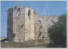
Part of a Wall
As the population of each extended, Philistines and Israelites obstructed the other's expansion and there were repeated clashes over the border. Afek, being in the middle, formed the scene of some famous Biblical battles (1 Samuel 4), which took place during the reign of the first Israelite king Saul.
At the first battle, Israel camped uphill at Ebenezer while the Philistines operated from the lower-lying Afek. The Israelites lost the battle, 30,000 soldiers are reported as having died. The Israelites suffered another tragic loss when the Holy Ark was captured by the Philistines. Later it would become one of the most important missions of king David to capture back the Ark.
The second battle against the Philistines likewise ended in defeat: Saul and his son Jonathan were captured at Mount Gilboa and their dead bodies were hung on the walls of Bet Shean (1 Samuel 29-31).
No further events were written about Afek in the annals of history until the occupation first by the Syrians and thereafter by the Babylonians, who also used it as a defence. After the Greek period, King Herod built a town "in the finest plain that was in his kingdom, and which had rivers and trees in abundance, and named it Antipatris (Josephus, Wars of the Jews, Book 1, 417)." He named the city Antipatris after his father, for whom he wanted to build a monument.
The Roman city of Antipatris lay on a cross-roads between the Roman capital of Caesarea and the capital of Juda, Jerusalem; again a location which would find itself in the midst of trouble. In the First Jewish War lots of battles between the Romans and the Jews were fought at Antipatris. At the end of the fighting the town lay in tatters (Josephus, Wars, Book 2: 515-550). An earthquake in the year 363 finally destroyed it.
After that, the Crusaders moved the settlement slightly more uphill and built their fort at the foot of the mountains. The Ottoman Turks moved back to the tel and built their fort on the top of it. The ruins are seen from the road between Rosh Ha'ayin and Petach Tikva; two centuries ago the fort was abandoned. After the British mandate, Afek lost its military function and a water installation was founded.
The Turkish fort, "Binar Bashi", still forms an impressing site. Parts of the towers and the entrances are still intact. The north-western tower gives out on a spectacular view of the Mekorot water reservoir; the water of the Yarkon river is controlled by a dam.
The opposite side of the fort gives out on the Roman city of Antipatris. The main road of the town, or the Cardo, forms a straight line from the eastern wall southwards. At the end of the road lay a small round theater, the Odeon. Shops and houses were built on each side of the road, which was paved in a herringbone pattern; many stones are still in place. The Roman city was excavated during several expeditions but most of it is now overgrown.
More difficult to see is the exciting knowledge that under the Turkish fort, built on top of each other and hidden in the tel, lie five (!) palaces from the Bronze Age. They are the cause of most of the archaeological hustle and bustle in Afek. The last palace belonged to the Egyptian governor(s) of Afek in the Late Bronze Era (1550-1200 BCE), part of it lies exposed along the western inner wall of the Turkish fort. The black lines along the walls indicate where reconstructions have been made. The residence consists of several chambers, one is a tower which is entranced via a flight of six steps from a paved courtyard. East to it is a passage of several meters wide, probably a street.
The governor's palace was destroyed, as witness traces of burning and arrowheads which stuck in the walls when archaeologists dug them up. The date of the destruction at the end of the 13th Century BCE could fit with the story in the Book of Joshua, but can also be a result of another local war in which the Israelites were not involved. In the residence, a treasure was found of other archaeological finds: books, including dictionaries in ancient languages which were used by the Egyptian governor's scribes; documents in ancient Hebrew, and Egyptian scarabs and seals.
Other sites on Afek's premises do not have archaeological interest but they are fun to discover. They include the British camp, built in 1935, which guarded the newly opened water project of the Jerusalem pipeline. The plant was deserted after a pump exploded in the War of Independence. In the fifties, the Israelis took over and built a dam in the Yarkon.
Another interesting site lies just outside Afek park. Nearby Rosh Ha'ayin is the settlement of Izbet Sarta (a little to the north), which is identified as Ebenezer. From the time of the Judges it was a forward settlement, its uphill situation used by the Israelites as a place to raid from at the Philistines. In the beginning Israeli progress was slow, however, not because of their position, but because the Philistines had superior equipment: they rode in chariots and they could make iron weapons far earlier than the Israelites. The finds from Izbet Sarta include a restored house from the 12th Century BCE (the early Israelite period). One of the oldest fragments in the Proto-Canaanite alphabet was found on a potsherd near centre of the settlement.
The ancient city of Tel Afek could not have existed without its source of water. In the past, water in Israel was less scarce; large rivers fed the country carrying millions of cubic meters each. Now this amount represents the total yearly amount of water in the whole country. Most rivers have dried up because the water is tapped excessively for agriculture and drinking water.
Of the few rivers which have survived in Israel, the Yarkon is the second largest, after the Jordan river. The water plant of the Mekorot company which taps the water of the Yarkon serves a huge amount of suppliers in Israel: that of the Central and South Region and Jerusalem.
Most people will know the Yarkon as the filthiest river in the country. One will probably be unpleasantly reminded of the disaster at the Maccabia sports event when athletes died after contact with the water, others think of rowing trips or romantic riverbank picnics next to badly reeking water. The river receives its pollution from the greater Tel Aviv industrial area. The river quality has badly deteriorated since 1955 when its water was led to irrigation projects in the Negev desert.
When coming to the park at Afek, visitors do not find such a bad situation. Fortunately there has been a considerable improvement of the water quality in recent years. A River Administration was set up, and scientists have been busy renovating the natural environment and introducing plants which have a cleansing effect on the water.
At the present only the middle part of the river along 13 kilometers is still very polluted, the end part (in Tel Aviv) and the source of the water in the Yarkon river park along 7.5 kilometers are now clean.
The natural beauty of the Yarkon has been restored in its Israeli form with eucalyptus trees and nice stretches of grass; which is not the native flora here, but that does not matter. The park now forms a more fitting background for the antiquities in Tel Afek, although the finds are a bit difficult to find as there are no indicating signs. This is a pity because now it would be easy to miss that Tel Afek is one of the most important biblical places in Israel.
Note: Tel Afek and Hayarkon River Park are two neighbouring parks which are connected by a trail along the river. To walk from one park to the other is possible on one ticket. At the entrance, check with the ticket employee that the fence between the two parks is open.
~~~~~~~
from the December 2000 Edition of the Jewish Magazine
|